Republic of Congo
Country Statistics


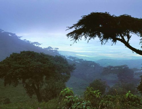
The Republic of Congo (RoC) is home to 22.5 million hectares of the Congo Basin forest. With low historical rates of deforestation and forests covering 69% of the land area, RoC is a typical example of a High Forest Cover and Low Deforestation (HLFD) country. However, accelerated development has led to major infrastructure projects that have opened up previously remote forest areas to economic activity. Some of the direct drivers of deforestation in RoC include logging, agro-industrial production (palm oil), slash-and-burn agriculture and mining.
Our Work
|
Country timeline
|
Third National Communication
First Biennial Update Report by 2022 New Forest Emissions Reference level / Forest Reference Level (FREL/FRL) (to be confirmed) |
|
Main activities in 2020
|
|
National context
Congo is currently working on the Third National Communication, whose submission was planned for the end of 2020. Support on the GHG inventory for the third National communication had already been provided during phase I of the Reporting for Results-Based REDD+ (RRR+) Project. The country aims to start the preparation of the first Biennial Update Report (BUR) for a planned submission by 2022. New data will be collected and included in the Greenhouse Gas inventory that will be included in the BUR and a new Forest Reference level.
Training: Improving Accuracy, Completeness and Consistency of Land Use and Land Use Change Data by 2021
During phase I of the RRR+ project, an assessment was made that Congo was lacking sufficient data to produce a complete, accurate and consistent Greenhouse Gas (GHG) Inventory for the Agriculture Forest and Other Land Use (AFOLU) sector. Prior to training, the country had only produced maps of land use and land use change that considered forest and non-forest categories to assess loss of forest cover over time. Under the Intergovernmental Panel on Climate Change (IPCC) guidelines, countries are requested to produce GHG inventory comprising six land use classes (Forest, Cropland, Grassland, Wetland, Settlement and Other Lands). To overcome this lack of information, it was agreed together with the national coordinator of the third National Communication and the first Biennial Update Report (BUR) that the country would set up a series of activities to collect and refine data for the Land use and land use change (LULUCF) sector. To help provide full expertise in this area, a partnership was set up between US Forest Service (USFS), UN Food and Agriculture Organization and CfRN. The goal was to train experts in using the new Collect Earth Online tool and establish a national protocol to collect data. The data collected would represent the six land use categories and provide information for the period 1990 to 2019. The new data collected would then be included in the GHG inventory that will be included in the first Biennial Report, which would also allow Congo to present a new Forest Reference Level consistent with its GHG inventory. This process started in March 2020 and is currently ongoing. The following activities were completed:
Workshop: Introduction to Collect Earth online and development of CEO protocol
Originally planned for March 2020, this workshop was postponed due to the Covid-19 pandemic. Due to current travel restrictions the support provided by FAO, USFS and CfRN was remote. National experts were able to meet and work together from a hotel in Brazzaville during the whole time of the workshop.
The goal of this workshop was to bring together national experts from the AFOLU working group for the third National Communication, CNIAF (abbreviation from French: Centre National d’Inventaire d’Aménagement des Ressources Forestières), the University of Marien Ngouabi of Brazzaville and the CRGEC (abbreviation from French : Centre de Recherche Géographique et de Production Cartographique). These experts will collect and refine the new LULUCF data. During the workshop, they were introduced to the tool Collect Earth Online through a series of exercises and discussed the implementation of a national procedure to collect data.
During the workshop, the presentation on good practice for sampling data was presented and the use of a systematic grid of 4 by 4 km was suggested to ensure a good assessment of land use change. This would imply the assessment of 21’000 plots during the data collection.


Support in the development of national protocol on data collection for the land use, land-use change and forestry (LULUCF) sector
During the workshop week, experts drafted the first protocol on data collection that will contain definition of national land use classes and the interpretation keys. National teams are still currently working in refining this protocol. The National classes were based on IPCC guidelines categories and specific national classes. Various levels of details were discussed by national experts to ensure the full representation of the land. Depending on the satellite images available the level of detail will be refined. The keys for interpretation allowed for a common interpretation of satellite images during the data collection with CEO. In this section experts provided concrete examples on how to determine the land use classes and the land use changes based on texture, color and refraction from satellite images. To ensure good quality of data collected, a quality control procedure was implemented. Discussion on how to establish such procedures have been taken place and a draft procedure is currently under national revision.
CfRN together with USFS and FAO organized the discussions, sharing templates and good practice examples as well and provided feedback on the draft procedure.
These activities will be followed by 45 days of data collection using Collect Earth Online.
Presentations on the reporting requirements under the new transparency framework (remote participation to the workshop organized by USFS-USAID)
Congo is currently finalizing the work of the third National Communication started in 2015. To assess status and ensure full compliancy with the international requirements under the UNFCCC, Congo, with the support of USFS-USAID, organized a workshop during the first week of October. All the stakeholders involved in the preparation of the third National Communication participated in that workshop. CfRN was asked to participate with providing two presentations. One of which was an overview of the new transparency frameworks under the Paris agreement and a second one on the REDD+ reporting requirements.
“The Republic of Congo is home to 22.5 million hectares of the Congo-Basin Forest. With low historical rates of deforestation and forests covering 69% of the land area, the Republic of Congo is a good example of a High Forest Cover and Low Deforestation (HLFD) country.”
“Ficias il etur? Igendae. Adiam que peles mi, vel id esto beaquatem facepra pro bere veris eiumquis comnim”

Species
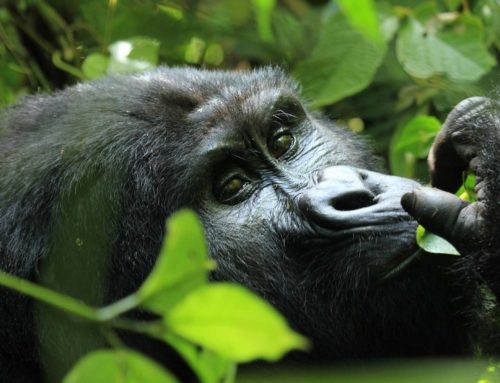
In 2006–07, researchers from the Wildlife Conservation Society studied gorillas in heavily forested regions centered on the Ouesso District of the Sangha Region. They suggest a population on the order of 125,000 western lowland gorillas, whose isolation from humans has been largely preserved by inhospitable swamps.
Useful Links
Background

Congo is located in the central-western part of sub-Saharan Africa, along the Equator. The capital, Brazzaville, is located on the Congo River, in the south of the country, immediately across from Kinshasa, the capital of the Democratic Republic of the Congo. The southwest of the country is a coastal plain for which the primary drainage is the Kouilou-Niari River; the interior of the country consists of a central plateau between two basins to the south and north. Forests are under increasing exploitation pressure. Congo had a 2018 Forest Landscape Integrity Index mean score of 8.89/10, ranking it 12th globally out of 172 countries. Congo lies within four terrestrial ecoregions: Atlantic Equatorial coastal forests, Northwestern Congolian lowland forests, Western Congolian swamp forests, and Western Congolian forest-savanna mosaic.